The island loop, landmark by landmark
Both shared airplane tours fly a full loop of Kauai from Lihue in about an hour, and the wind and cloud decide which way round you go. This guide takes the island one area at a time, with what each landmark looks like from a small plane and which operator lists it. Read it before you fly and you will know what the pilot is pointing at.
How the loop works
Both shared flights take off from Lihue Airport on the east side and circle the whole island, about 550 square miles of it, before landing where they started. Neither promises a direction. The pilot sets the order on the day by the wind and by where the cloud is sitting, so this guide groups the sights by area rather than in flight order.
The two operators describe the loop differently. Air Ventures publishes the longer list of sights, while Wings Over Kauai puts its weight on the Na Pali Coast, and its listing says the plane spends about 15 minutes along it. One Air Ventures reviewer reports a route that cut inland across the north instead of tracing the whole coast, a reminder that the plan bends to the weather.
The Na Pali Coast
This is the stretch most people book for. Fluted cliffs run for some 17 miles (27 km) along the north-west shore of the Na Pali Coast, and the tallest of them climb to around 4,000 ft (1,200 m) from the water's edge. No road reaches it. On the ground you can walk part of it on the Kalalau Trail, which runs about 11 miles (18 km), or see it from a boat offshore. The plane is the one way to take in the whole length at once.
Watch for the Kalalau Valley, where the trail ends, opening wide behind its beach. Lower down, the waterline is cut with sea caves and arches that a boat passes close and a plane shows you from above. The ridges look sharpest when the sun comes from the side, and best months and hours to fly explains when the Na Pali light is kindest.
Waimea Canyon and the west
Waimea Canyon stretches some 10 miles (16 km), its floor up to about 3,000 ft (900 m) below the rim, and it gets called the Grand Canyon of the Pacific for good reason. From the road you see it from a lookout on the rim. From the air you look down its length, with red walls and green slopes folding into side gorges. Cloud can fill it, though, and reviewers on both flights mention days when the pilot skipped the canyon because nothing could be seen.
Air Ventures also lists Waimea town, where Captain Cook landed in 1778, and its GetYourGuide itinerary adds Hanapepe Valley. On a clear day, look west for Niihau on the horizon, the privately owned island often called the Forbidden Island.
Manawaiopuna Falls
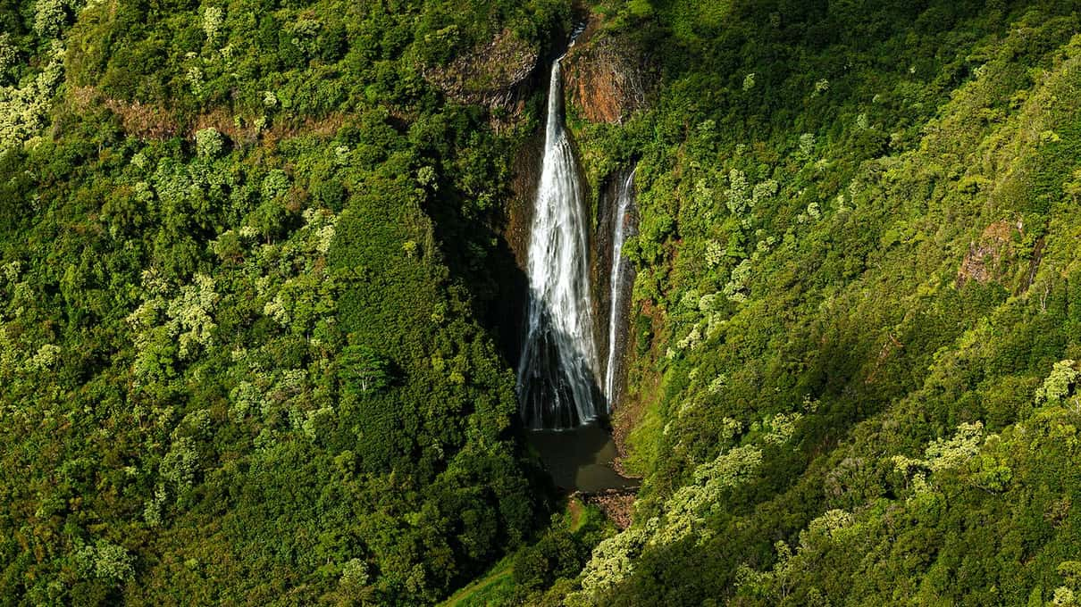
Manawaiopuna Falls, in Hanapepe Valley, plunges about 400 ft (120 m) into a green bowl of forest. The land around it is private and closed to hikers, and most people know it from Jurassic Park, which filmed there in 1993. From the plane it appears as a white thread against the jungle, and it is best seen from the air because the air is the only practical way in. Both shared flights list it, with Wings Over Kauai adding "weather permitting".
Mount Waialeale and the crater
The island's center belongs to Mount Waialeale, which tops out near 5,148 ft (1,569 m) and gets more rain than almost anywhere on the planet. Nearby Kawaikini, about 5,243 ft (1,598 m), is the true summit of Kauai. When the cloud lifts, the crater below Waialeale shows a curved wall streaked with thin waterfalls. When it stays down, you fly past a grey wall, and no pilot can change that. The private Cessna listing says that on clear days it can cross near the summit and the Waialeale waterfalls.
The itinerary with the most names
Air Ventures names the most landmarks of the three airplane itineraries, from the Menehune Fishpond to Lumahai Beach, on a 65-minute loop from ~$159. Either site lets you cancel without charge up to a day before.
The north and east shores
On the north side, Hanalei Bay bends round in a long crescent of sand, backed by the flat taro fields of Hanalei Valley spread out in a patchwork under the mountains. Wings Over Kauai lists the waterfalls of Hanalei Valley. Air Ventures adds Lumahai Beach and little Mokuaeae Island, along with the lighthouse at Kilauea Point, built in 1913 on a headland over the sea.
Further round, the Anahola mountains hold a ridge that locals see as the profile of King Kong, a stop on the Air Ventures itinerary. Closer to Lihue come Wailua Falls, about 80 ft (24 m) and often a twin fall, and Opaekaa Falls nearby. Just outside town sits the old Menehune Fishpond, also called Alekoko, an old stone-walled fishpond beside the river.
The south shore
The south coast gets less attention than Na Pali, but both shared flights cover it. Wings Over Kauai lists Kipu Kai and the Poipu shoreline, and Air Ventures adds Mahaulepu Beach along with the Tunnel of Trees and Waita Reservoir inland. Kipu Kai is a secluded valley and beach tucked behind a ridge, and from the plane you see a corner of the island that few visitors reach by land. In winter, roughly December to April, humpback whales spend the season in Hawaiian waters, and Wings Over Kauai's listing mentions whale watching. Look for spouts and white splashes on the blue.
When the cloud has a say
No flight sees every landmark every day. Waialeale is the sight most often lost to cloud, and Waimea Canyon sometimes goes too. The pilot decides where to fly and when to turn back, and a good one will swap a hidden canyon for a longer pass along a clear coast. The side you sit on matters as well, since reviewers say the left seats see more open ocean on parts of the loop; window seats and the weigh-in explains why. For pictures that do the cliffs justice, read photos through a plane window, and if you are still deciding on the aircraft, airplane or helicopter over Kauai sets the plane's wide loop against a helicopter's closer look.